EUROSEISTEST
DATABASE
Geotechnics/Geophysics
An extensive geophysical and geotechnical in-situ and laboratory campaign was conducted in EUROSEISTEST during the years of its operation (Figure 1). The scope of the campaign was to define the geological-geotechnical structure of the whole valley and the dynamic properties of the soil.
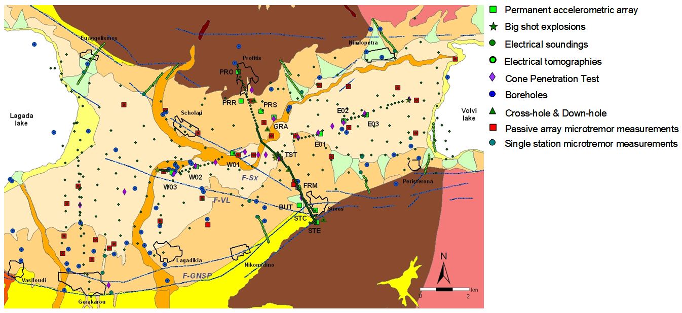
Figure 1: Geophysical and geotechnical surveys performed in the Mygdonia basin during its 20 years of operation.
In total 1100m of geotechnical
boreholes have been drilled in the Mygdonia basin. Several in hole tests have been
contacted namely Down-Hole (DH) and Cross-Hole (CH)
tests (Table 1) to determine the Vs profile mainly along the North-South
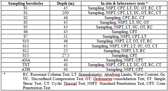
direction of the valley. Geotechnical surveys and tests comprise sampling
boreholes, in-situ tests (NSPT and CPT) and high quality laboratory tests
(classification tests, resonant column, triaxial, consolidation, unconfined
compression and cyclic triaxial tests). The statistical process of all dynamic
tests lead to the determination of G/Go-γ-D(%) curves for all soil types.
Table 2 summarizes the in-situ and laboratory geotechnical tests in the
valley.
Table 1. Borehole geophysical surveys conducted in the Mygdonia basin.
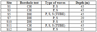
Table 2. Laboratory and in-situ geotechnical surveys conducted in the valley.
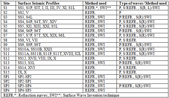
Furthermore, 20.5 km of
surface seismic investigations were performed in order to
calculate the Vs and Vp velocities of its main geological formations. 12 km of
these surveys were conducted in the North-South direction (in between villages
Profitis and Stivos) and the rest 8.5 km along the East-West direction (Figure
1). These investigations included P- and S-wave
refraction and Surface Wave Inversion surveys. Surface Wave Inversion method provided the majority of the Vs velocities
and the geometry of the lateral discontinuities at the basin edges (Raptakis,
1995; Raptakis et al. 1998; Jongmans et al., 1998; Raptakis et al., 2000).
Table 3 shows the seismic methods, profiles, and seismic waves used in these
surveys.
Table 3. Surface seismic profiles deployed along the valley.
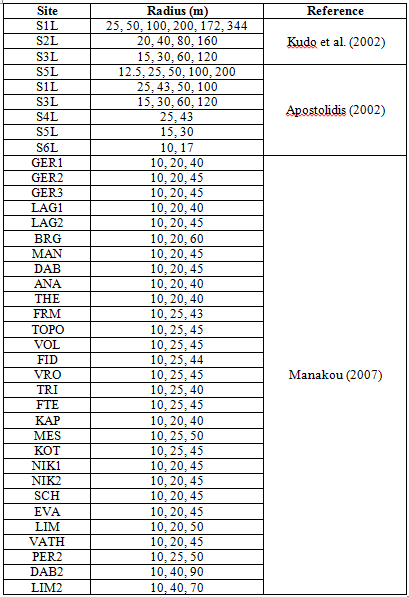
Finally, 38 passive array microtremor measurements using the SPatial Autocorrelation method, SPAC (Aki, 1957), were performed to estimate Vs velocities of the soil within the basin (Table 4, Figure 1) (Kudo et al., 2002; Apostolidis, 2002; Manakou, 2007, Manakou et al. 2010). The ambient noise was recorded using triaxial broad-band accelerometers and seismometers with high resolution recording systems.
Table 4. SPAC Array Microtremor measurements conducted within the basin.
References
Aki K. (1957). Space and Time Spectra of Stationary Stochastic Waves, with Special Reference to Microtremors. Bull. Earthquake Res. Inst. Tokyo Univ. 25, 415-457.
Apostolidis P. (2002). Definition of the soil structure using microtremors. Estimation of the dynamic properties and geometry of soils in Thessaloniki, PhD Thesis (in Greek with English abstract), Department of Civil Engineering, Aristotle University of Thessaloniki.
Jongmans D., K. Pitilakis, D. Demanet, D. Raptakis, J. Riepl, C. Horrent, K. Lontzetidis and P.-Y. Bard (1998). EURO-SEISTEST: Determination of the geological structure of the Volvi basin and validation of the basin response, Bull. Seism. Soc. Am. 88(2), 473-487.
Kudo K., T. Kanno, H. Okada, T. Sasatani, N. Morikawa, P. Apostollidis, K. Pitilakis, D. Raptakis, M. Takahashi, S. Ling, H. Nagumo, K. Irikura, S. Higashi and K. Yoshida (2002). S-Wave Velocity Structure at EURO-SEISTEST, Volvi, Greece Determined by the Spatial Auto-Correlation Method applied for Array Records of Microtremors, Proc. 11th Japan Earthquake Engineering Symposium, Paper No. 62.
Manakou M. (2007). Contribution of the determination of a 3D soil model for the site response study. Application to the sedimentary Mygdonian basin. PhD thesis (in Greek), Department of Civil Engineering, Aristotle University of Thessaloniki.
Manakou M., D. Raptakis D., F. J. Chavez-Garcia, P. Apostolidis and K. Pitilakis (2010). 3D soil structure of the Mygdonian basin for site response analysis, Soil Dynamics and Earthquake Engineering 30, 1198-1211.
Raptakis D. (1995). Contribution to the determination of the geometry and the dynamic properties of soil formations and their seismic response. PhD thesis (in Greek with English abstract), Department of Civil Engineering, Aristotle University of Thessaloniki.
Raptakis D., N. Theodulidis and K. Pitilakis (1998). Data Analysis of the EURO-SEISTEST Strong Motion Array in Volvi (Greece): Standard and Horizontal-to-Vertical Spectral Ratio Techniques, Earthquake Spectra 14(1), 203-223.
Raptakis D., F. J. Chávez-García, K. Makra and K. Pitilakis (2000). Site effects at EUROSEISTEST Part I. Determination of the valley structure and confrontation of observations with 1D analysis, Soil Dynamics and Earthquake Engineering 19, 1-22.