EUROSEISTEST
DATABASE
Geology/Tectonics
At present, the Mygdonia basin is subjected to the N-S extension of the Aegean Sea and the westward movement of the North Anatolia Fault. The main active faults in the area strike in NW-SW, E-W or ENE-WSW direction. The E-W trending faults are mainly dip-slip, while the NW-SW and ENE-WSW occasionally show strike-slip components of movement.
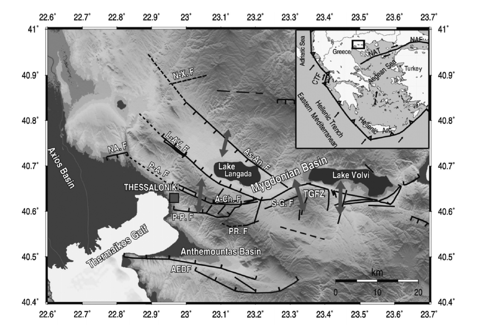
Figure 1: Neotectonic faults (after Tranos et al., 2003) and extensional velocities (arrows; Papazachos et al., 2001) for the broader EUROSEISTEST area. Figure is from Paradisopoulou et al. (2006) and more information on individual seismotectonic features can be found therein.
The fault zone forming the southern boundaries of the Mygdonia graben, was in fact related to 1978, M6.5 earthquake which affected the epicentral area, as well as the city of Thessaloniki. The locations of the largest events of the 1978 earthquake sequence are shown in Figure 2.
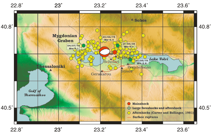
Figure 2: Map showing the broader region of occurence of the 20 June 1978 (M6.5) earthquake sequence. Epicenter and focal mechanism (Liotier, 1989) of the mainshock (red) and epicenters of the largest events of the sequence (green, yellow) (Carver and Bollinger, 1981) are also depicted. Dotted lines mark the Mygdonia graben and surface ruptures after the 1978 earthquake (Mountrakis et al., 1983) are shown as red lines.
References
- Carver, D. and G. A. Bollinger (1981). Aftershocks of the June 20, 1978, Greece earthquake: a multimode faulting sequence, Tectonophysics 73, 343 - 363.
- Liotier, Y. (1989). Modelisation des ondes de volume des seismes se l'arc Ageen, DEA de l'Universite Joseph Fourier, Grenoble, France (in French).
- Mountrakis, D., A. Psilovikos and B. Papazachos (1983). The geotectonic regime of the 1978 Thessaloniki earthquakes, In: Papazachos, B. C. and P. G. Carydis (eds.), The Thessaloniki, Northern Greece, earthquake of June 20, 1978 and its seismic sequence, Technical Chamber of Greece, 11 - 27.
- Paradisopoulou. P. M., V. G. Karakostas, E. E. Papadimitriou, M. D. Tranos, C. B. Papazachos and G. F. Karakaisis (2006). Microearthquake study of the broader Thessaloniki area (Northern Greece), Annals of Geophysics 49(4/5), 1081 - 1093.
- Papazachos C. B., D. A. Vamvakaris, G. N. Vargemezis and E. V. Aidona (2001). A study of the active tectonics and deformation in the Mygdonia basin (N. Greece) using seismological and neotectonic data, Bull. Geol. Soc. Greece XXXIV, 303 - 309.
- Psilovikos A. (1977). Paleogeographic development of the basin and lake of Mygdonian (Lagada - Volvi area, Greece), PhD Thesis, Department of Geology, Aristotle University of Thessaloniki (in Greek).
- Raptakis D., M. Manakou, F. J. Chavez-Garcia, K. Makra and K. Pitilakis (2005). 3D configuration of Mygdonian basin and preliminary estimate of its site response, Soil Dynamics and Earthquake Engineering 25, 871 - 887.
- Sotiriadis L., A. Psilovikos, E. Vavliakis and G. Syrides (1983). Some Tertiary and Quaternary basins of Macedonia/Greece. Formation and evolution, Clausthaler Geologische Abhandlungen, pp 21.
- Tranos M. D., E. E. Papadimitriou and A. A. Kilias (2003). Thessaloniki-Gerakarou Fault Zone (TGFZ): the western extension of the 1978 Thessaloniki earthquake fault (Northern Greece) and seismic hazard assessment, J. Struct. Geol. 25, 2109 - 2123.